—Italiano sotto—
Abstract
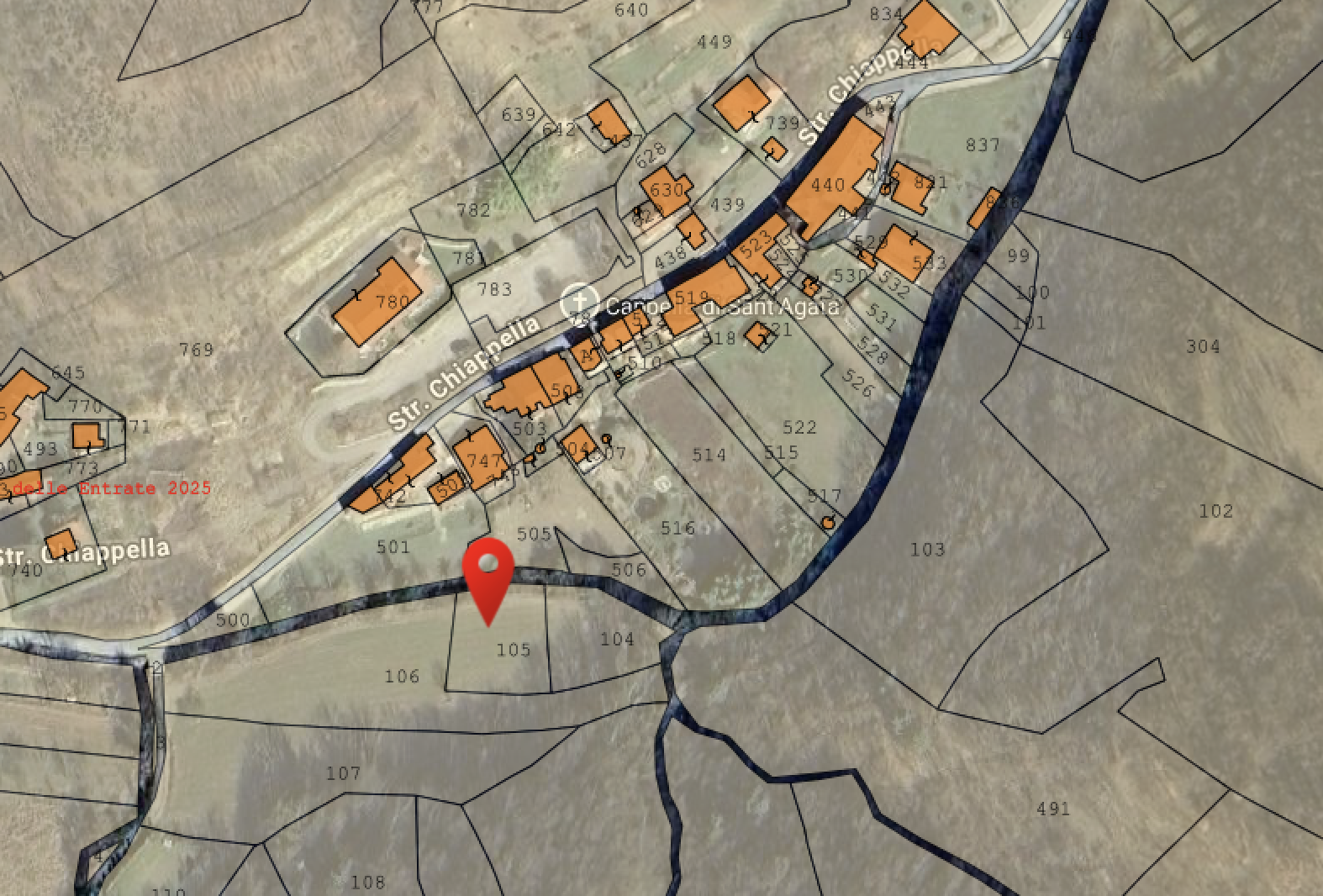
This document outlines the characteristics of the Terreni oltre Torrente, two agricultural plots located across the stream. Due to their flat nature and proximity to water, these lands have been officially designated as the grazing and management area for the horses residing at ColivingLiguria.
- Location: Google Maps | Coordinates: 44°24’07.7”N 8°15’10.6”E
- Land Registry: Foglio 46, Particelle 104 & 105 (Total Area: 1,240 m²)
Description and Potential Use
The property consists of two agricultural plots:
- Particella 104 (600 m²): Half of it is woodland, offering potential for wood harvesting.
- Particella 105 (640 m²): Already cleared of wood.
Being flat and close to the stream, these lands are particularly suitable for agricultural purposes and grazing. They are the designated home for the horses of the ColivingLiguria community. Upcoming work will focus on preparing this area to safely host the animals. You can read the detailed preparation plan on the Terrain Setup Plan page.
Buildability (CDU Verification): According to the CDU 2025/102, these lands fall under Zone E (Agricultural).
- Residential Construction: Excluded due to the ANI-MA classification.
- Agricultural Construction: Permitted with a low land utilization index ( ). This allows for small agricultural structures, such as shelters for the horses or tool sheds, subject to specific project approval.
Access and Connection Strategies
Access to these plots presents some logistical challenges that we plan to address during the Terrain Setup Plan phase.
- Vehicle Access: The municipal road (Str. Chiappella) leads towards the stream but ends near plot 106, which is not owned by us. We need to verify the possibility of accessing our lands (104 & 105) by passing directly through plot 106.
- Connection for Horses: To connect the grazing area (104 & 105) with the main property, we are exploring a path along the stream bank. The goal is to create a route that leads from these plots directly to Particella 522, the land situated right in front of Casa del Noce. This would allow for easier management of the animals.
Risks and Verifications
- Pre-emption Rights: These lands are likely subject to Agricultural Pre-emption Rights. We are currently investigating this risk.
- Hydrological Risk: Official hydrological risk assessments are pending. However, empirical observation during the major flood of September 2025 showed no apparent damage to these lands.
Abstract
Questo documento delinea le caratteristiche dei Terreni oltre Torrente, due lotti agricoli situati oltre il torrente. Grazie alla loro natura pianeggiante e alla vicinanza all’acqua, questi terreni sono stati ufficialmente designati come area di pascolo e gestione per i cavalli che risiederanno a ColivingLiguria.
- Posizione: Google Maps | Coordinate: 44°24’07.7”N 8°15’10.6”E
- Dati Catastali: Foglio 46, Particelle 104 & 105 (Superficie Totale: 1.240 m²)
Descrizione e Potenziale d’Uso
La proprietà è composta da due lotti agricoli:
- Particella 104 (600 m²): Per metà boschivo, con potenziale per il taglio della legna.
- Particella 105 (640 m²): Già privo di vegetazione ad alto fusto.
Essendo pianeggianti e vicini al torrente, questi terreni sono particolarmente adatti per fini agricoli e per il pascolo. Sono infatti la casa designata per i cavalli della comunità di ColivingLiguria. I prossimi lavori si concentreranno sulla preparazione di quest’area per ospitare gli animali in sicurezza. Puoi leggere il piano dettagliato per la sistemazione nella pagina Terrain Setup Plan.
Edificabilità (Verifica CDU): In base al CDU 2025/102, questi terreni ricadono in Zona E (Agricola).
- Edificazione Residenziale: Esclusa, in quanto l’area è soggetta al regime ANI-MA.
- Edificazione Agricola: Consentita con un indice di utilizzazione fondiaria basso ( ). Questo potrebbe permettere la realizzazione di piccole strutture agricole, come ripari per i cavalli o attrezzi, previa approvazione del progetto.
Accesso e Strategie di Collegamento
L’accesso a questi terreni presenta alcune sfide logistiche che pianifichiamo di affrontare durante la fase di Terrain Setup Plan.
- Accesso Carrabile: La strada comunale (Str. Chiappella) permette di avvicinarsi con i mezzi, ma porta soltanto fino al terreno 106, che non è di nostra proprietà. Dovremo verificare la possibilità di accedere direttamente ai nostri terreni (104 e 105) passando attraverso il 106.
- Collegamento per i Cavalli: Per collegare l’area pascolo (104 e 105) con la proprietà principale, stiamo valutando un passaggio lungo il torrente. L’obiettivo è creare un percorso che arrivi fino alla Particella 522, ovvero il terreno situato proprio di fronte alla Casa del Noce. Questo faciliterebbe enormemente la gestione quotidiana degli animali.
Rischi e Verifiche
- Prelazione Agraria: Questi terreni sono i principali sospettati per la Verifica Prelazione Agraria. Siamo in fase di ricerca per escludere tale rischio.
- Rischio Idrologico: Le valutazioni ufficiali sul rischio idrogeologico sono in attesa. Tuttavia, a livello empirico, l’alluvione del settembre 2025 non ha causato danni evidenti a questi terreni.